


Quantum Navigation Without GPS: Swiss Research Enters a Wider Positioning Trial

Updated: Sep 6
A second way to know where you are
For decades, navigation has depended on signals from satellites. A receiver compares carefully timed transmissions from several spacecraft and calculates its position. That arrangement is remarkably convenient, but it is not invulnerable: satellite signals are weak by the time they reach Earth and can be blocked, imitated or denied. Dense terrain, underwater operation, deliberate jamming and spoofing can all turn a reliable position into a dangerous guess.[2]
Quantum navigation offers a different principle. Instead of waiting for a radio signal from orbit, a vehicle carries a sensor that measures motion or a local feature of Earth’s physical environment. The relevant information can come from atoms in free fall, or from subtle variations in gravity and magnetism. A computer then compares those measurements with a reference model or map.
Recent trials have moved the idea beyond laboratory demonstrations. An Australian company, Q-CTRL, reported a GPS-free maritime test in the Coral Sea in August 2026, while European programmes have spent years reducing atom-interferometer instruments for aircraft and ships.[1] [3] Swiss researchers are contributing to the enabling science, although the public sources reviewed for this report do not identify a Swiss institution as a participant in Q-CTRL’s Australian sea trial. That distinction matters: Switzerland’s role is best described as part of the research base behind portable quantum sensing, not as a confirmed member of that particular crew or consortium.
What the sensor measures
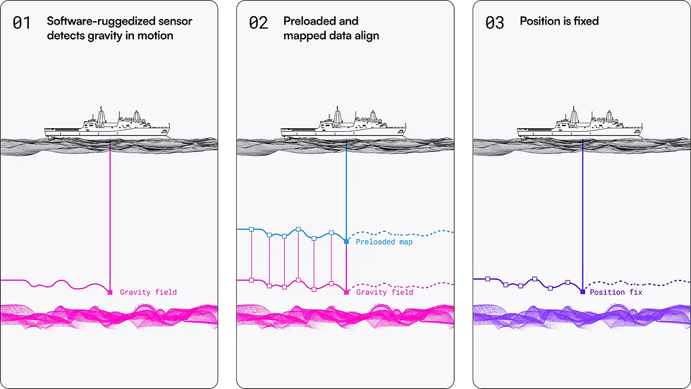
A cold-atom interferometer uses lasers and magnetic fields to prepare a cloud of atoms, place the atoms in a quantum superposition and interrogate their subsequent motion with laser pulses. The resulting interference pattern contains information about acceleration, rotation or gravity. Inertial measurements can be integrated with a starting position to estimate a vehicle’s movement without an outside signal. Gravity-aided navigation adds another layer: the instrument looks for local variations in Earth’s gravitational field and matches them against a map.[3]
Earth’s gravity is not uniform. Rotation, geology, topography, ocean structure and even large human-made features alter the local field. Those variations are usually too small for an ordinary navigation instrument, but they form a physical fingerprint. A vessel moving across a mapped region can compare a sequence of readings with the expected pattern and correct the drift of its inertial system.[3]
Navigation method | External signal required during operation | Main measurement | Principal weakness addressed by quantum approaches |
Satellite navigation | Yes | Timed radio signals from GNSS satellites | Vulnerable to obstruction, jamming and spoofing |
Conventional inertial navigation | No | Accelerometers and gyroscopes | Position error grows through sensor drift |
Quantum inertial navigation | No | Atom interference caused by acceleration and rotation | Seeks lower drift, but must withstand vibration and motion |
Gravity-aided quantum navigation | No | Local gravitational variations matched to a map | Requires sufficiently detailed maps and distinctive field features |
Magnetic-aided navigation | No | Local magnetic signatures of Earth and infrastructure | Signals can vary with environment and magnetic interference |
The Swiss connection: making quantum sensors practical
One relevant Swiss contribution comes from ETH Zurich. In a study reported by the university in August 2025, researchers trapped a cluster of nanoparticles with an optical tweezer inside a vacuum chamber. They achieved a high level of quantum purity at room temperature, attributing 92 percent of the cluster’s measured motion to quantum physics and 8 percent to classical effects.[4]
The experiment was not a navigation trial. ETH presented it as fundamental research with possible future uses in force sensing and motion sensors that could help vehicles navigate when contact with a GPS satellite is unavailable.[4] Its importance lies in the engineering direction: a navigation instrument must eventually be compact, stable and useful outside a carefully controlled laboratory. Avoiding cryogenic cooling, reducing noise and controlling larger objects could all help close that gap.
The challenge is substantial. Quantum sensors are highly sensitive by design, which also makes them sensitive to vibration, rotation, temperature changes and electromagnetic interference. A ship’s engine, wave motion or aircraft turbulence can overwhelm the effect being measured. Systems therefore need isolation, rapid data processing and a way to combine quantum readings with conventional sensors.
ESA’s NAVISP programme describes this hybrid approach. A consortium led by iXblue developed a compact three-axis cold-atom interferometer for possible use on boats, aircraft and fixed sites. The project paired quantum measurements with a mechanical accelerometer to reduce the “dead time” between atom clouds and to increase the sensor’s dynamic range.[3] In parallel, the Quantum Wayfarer project studied whether gravity-map matching could work in real navigation conditions. The results indicated that areas with stronger gravity gradients should provide more distinctive signatures than comparatively flat regions.[3]

The maritime test in the Coral Sea
Q-CTRL’s August 2026 announcement describes a separate, open-water demonstration. The company says its Ironstone Opal system used a software-ruggedized quantum gravimeter installed in a passenger cabin. The vessel mapped gravity autonomously and then used gravity-aided navigation without GPS. Q-CTRL reported one-nautical-mile positioning accuracy over the mission duration and said this was more than ten times better than navigation-grade GNSS backup systems.[1]
The system’s logic is passive. It does not need to transmit a signal or receive a satellite signal to establish its position. It observes the local gravitational field and compares the observation with a gravity map. That makes jamming and spoofing much harder than they are against a conventional radio-navigation receiver, although it does not eliminate every source of error. The system still depends on sensor quality, map resolution, ocean conditions, computational models and the ability to distinguish one location from another.
Q-CTRL says the equipment operated in heavy seas without dedicated temperature control, gyroscopic motion stabilisation or frequent recalibration.[1] Those claims are significant because a field system must work continuously rather than produce a single precise measurement in a quiet laboratory. They should nevertheless be read as the company’s reported results until the linked technical paper and independent reproductions are assessed in detail.

Trial, not replacement
It would be premature to describe quantum navigation as a wholesale replacement for GPS. The World Economic Forum’s review of UK tests in a Royal Navy ship, a small aircraft and London’s Underground concluded that quantum instruments were being developed primarily as resilient backups. The same review noted that cold-atom equipment remained sizable and that satellite navigation was still exceptionally convenient.[2]
A practical navigation suite will probably combine several sources. GNSS can provide an efficient global fix when its signals are trustworthy. Classical inertial sensors can deliver rapid motion data. Quantum accelerometers or gravimeters can correct accumulated drift, while magnetic or gravity maps can supply position updates in places where satellites are unavailable. This layered architecture reduces reliance on any single technology.
Map quality will be decisive. ESA reported that global gravity maps available to the NAVISP work had a baseline accuracy of roughly 90 metres, with potential improvement toward 30 metres, and that performance varied with the local gravity gradient.[3] A sensor cannot identify a position reliably if nearby locations have nearly identical signatures or if the reference map is too coarse. Surveying, updating and securing those maps will therefore be as important as improving the quantum device itself.
The first users are likely to be organisations for which loss of positioning is expensive or dangerous: naval and commercial ships, aircraft, autonomous vehicles, emergency services and underground transport. Underwater vehicles are a particularly clear case because satellite signals do not travel effectively through seawater. Civilian road navigation, by contrast, may continue to favour inexpensive satellite receivers augmented by inertial and map data.
Why the Swiss role matters
Switzerland’s research ecosystem is relevant because quantum navigation depends on more than a single sensor. It requires quantum control, precision optics, vacuum engineering, low-noise measurement, modelling and robust software. ETH Zurich’s room-temperature nanoparticle experiment illustrates one route toward sensors that may become easier to deploy.[4] European navigation programmes show the parallel systems-engineering route: combine quantum and classical instruments, compensate for motion and compare readings with environmental maps.[3]
The distinction between research participation and trial participation should remain explicit. The sources used here confirm a Swiss laboratory advance with potential navigation relevance, and they confirm European field-oriented development. They do not confirm that Swiss researchers took part in Q-CTRL’s Coral Sea voyage. A responsible account should not turn a promising national research contribution into an unverified claim about a specific sea trial.
Quantum navigation is therefore best understood as a resilience technology. It does not make satellites obsolete, and it does not remove the need for maps, calibration or careful error analysis. Its promise is narrower and more practical: when satellite navigation is blocked, deceived or unavailable, a vehicle may still be able to infer how it is moving and where it is by reading the physical signatures around it.
Video references
The following videos provide visual and educational context rather than independent proof of the specific Coral Sea result:
Quantum Sensors for Navigation – From Physics to Field Deployment, Institute for Quantum Studies, 2025. The presentation connects atom-interferometer physics with positioning and navigation applications.
Quantum Navigation Is Here: How Cold Atoms Could Replace GPS, 2025. A general explainer on cold atoms, quantum accelerometers and GPS-denied navigation.
ESA probing navigation via the quantum realm, ESA. The page includes an “Access the video” link and explains the NAVISP projects behind compact cold-atom sensors.
References
https://q-ctrl.com/blog/q-ctrl-achieves-worlds-first-gps-free-quantum-gravimetric-navigation-demonstration-in-maritime-field-trial — Q-CTRL, “Q-CTRL Achieves World’s First GPS-Free Quantum Gravimetric Navigation Demonstration in Maritime Field Trial,” 27 August 2026.
https://www.weforum.org/stories/emerging-technologies/what-is-quantum-navigation-earth-observation/ — World Economic Forum, Madeleine North, “What is quantum navigation – and could it replace GPS?”, 5 July 2024.
https://www.esa.int/Applications/Satellite_navigation/ESA_probing_navigation_via_the_quantum_realm — European Space Agency, “ESA probing navigation via the quantum realm,” 14 March 2022.
https://ethz.ch/en/news-and-events/eth-news/news/2025/08/pure-quantum-state-without-the-need-for-cooling.html — ETH Zurich, Fabio Bergamin, “Pure quantum state without the need for cooling,” 6 August 2025.
Comments